
China's High-Altitude Heliports In Tibet A Sobering Reminder of Threat To India Along LAC
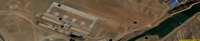
An under-construction heliport in Gar County
The military dynamics of Tibet are undergoing a fresh change with the construction of high-altitude helicopter infrastructure in the area
Prof (Dr) Y Nithiyanandam
The Tibetan Autonomous Region (TAR) presents unique challenges for air infrastructure superiority, with its high altitude and rugged terrain. While the expansion of airports and deployment of fighter jets and sophisticated radar systems have been traditional measures of this superiority, a less recognised but equally critical aspect is China's increasing rotary-wing capabilities at extreme altitudes.
Our research reveals that nearly 90% of heliports in the TAR are located at elevations between 3,300 and 5,300 m (10,000–17,400 ft), with 80% concentrated above 3,600 m. These advancements signal that China's once-significant limitations in helicopter operations at such altitudes are swiftly diminishing.
China's critical military infrastructure at higher altitudes is rapidly expanding in the challenging environment of the TAR. A vital part of this expansion is the proliferation of high-altitude heliports and helipads, which are quickly becoming crucial nodes in the People's Liberation Army (PLA) ground and air operations strategy.
These helipads, strategically placed near the Line of Actual Control (LAC) between India and China, disputed areas with Bhutan, and critical infrastructure like surface-to-missile (SAM) sites and military barracks, serve as logistics hubs. Their role in facilitating rapid troop and equipment movement underscores their strategic significance.
The figure above shows the distribution of 109 helipads based on their elevation. Surprisingly, only two helipads are positioned at an elevation of 780 to 2600 m. However, 32 helipads are located between 2700 and 3600 m, 44 helipads between 3700 and 4300 m, and 25 helipads between 4400 and 4700 m. Six more helipads are positioned at elevations between 4800 and 5400 m. These helipads exhibit a wide range of elevations, from a minimum of 780.50 m to a maximum of 5374 m, with an average elevation of approximately 3930 m.
Once considered to be a handicap in PLA's air operation, China's high-altitude capabilities have seen a significant and rapid expansion. This development underscores the urgency of the situation and the growth of the PLA's air operations in a way that cannot be ignored.
A new approach of extending heli strips to allow Unmanned Aerial Vehicles (UAVs) to land on strips shorter than 1,000 m highlights China's forward-thinking military infrastructure, making these sites useful for both helicopters and UAVs.
Over the past decade, the PLA has substantially invested in helicopter infrastructure, which has increased its operational capability. These expenses are not merely reactions to disputes like the 2017 Doklam standoff or the 2020 Galwan Valley clash. Instead, they are a calculated approach aimed at guaranteeing long-term gains in a zone where the topography and elevation seriously challenge the PLA's troops.
For example, the Z-20 and Z-8L helicopters have been specially built to operate under the difficult circumstances of the Tibetan plateau, highlighting China's will to overcome the obstacles presented by the hostile surroundings.
Modernising And Expanding: A Strategic Choice
While the rate of heliport construction is slower than the growth of airfields, it reflects the PLA's approach of aggressively expanding its military infrastructure. Some of the heliports studied in our research are undergoing infrastructure upgrades/expansion, while a few are newly established.
The figure above shows helipads/heliports and aerodromes located 5, 10, 25, 50, 100, and 200 km from the LAC. The spacing of these heliports highlights their strategic importance.
Heliport concentrations close to the LAC and other disputed regions highlight their importance in supporting ground operations and preserving a continuous military presence in disputed territory. Combining these heliports with other military installations, such as radar stations and Surface-to-Air Missile (SAM) sites, can create a dense network of military capabilities that can be rapidly mobilised in response to any border escalation.
These heliports' proximity to the Indian border allows the PLA to quickly deploy hop-on, hop-off forces in case of a confrontation, matching Indian defences in high-altitude locations with supply lines and logistics. Over the years, China may have a significant advantage over its neighbours if it keeps constructing such infrastructure at this rate. This underscores China's long-term approach to defending its territorial claims and establishing hegemony by incorporating these heliports in a more extensive military infrastructure network.
These advances will impact the strategic calculus in the Himalayan borderlands, serving as a sobering reminder of how the threat is changing for India along its northern front. As the PLA keeps improving its capacity in Tibet, India must react with similar steps to guarantee it is ready to handle the difficulties presented by China's growing military presence in the Himalayas.
Prof (Dr) Y Nithiyanandam heads the geospatial research program at the Takshashila Institution, Bangalore

