
ISRO Releases Satellite Image Based Study of South Lhonak Lake That Caused Sikkim Floods
Date wise Images of Sourth Lhonak Lake
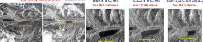
Approximately 65 percent of Sikkim's Lhonak Lake, covering around 105 hectares, has experienced significant drainage due to a cloudburst, causing the lake to overflow and triggering flash floods in the Teesta River.
Temporal satellite images from the Indian Space Research Organisation (ISRO) released on Wednesday, 4th October show dramatic changes in the lake's water volume. Photos taken on September 17 and September 28 indicate the lake's size at 162.7 hectares and 167.4 hectares, respectively.
However, an image captured on the morning of 4th October, after the cloudburst and flash floods, reveals that the lake has been reduced by more than half, with an estimated 60.3 hectares of water remaining.
ISRO stated, "Temporal changes in the lake area - as on September 17, September 28, and October 4. It is observed the lake is burst and about 105 hectares has been drained out, which might have created a flash flood downstream... will continue monitoring the lake using the satellite data."
The flash floods have resulted in at least eight fatalities, with three bodies discovered hundreds of kilometers downstream in north Bengal. The other five victims were found in various areas of Sikkim.
Additionally, 23 soldiers are currently missing, and a joint rescue operation involving the Army and local officials has been launched. Fortunately, 45 individuals have been rescued, but 18 of them have sustained injuries as reported by PTI.
Sikkim experienced heavy rainfall overnight, with the northern part of the state, where the lake is located, receiving nearly 50 mm of rainfall on Sunday, 1st October, which was 48 percent higher than normal. Other parts of the state experienced even more significant rainfall, with eastern areas receiving 315 percent more rainfall than usual, and South Sikkim witnessing a staggering 943 percent increase. West Sikkim received 50 percent more rain than average.
The cloudburst over Lhonak Lake not only caused the lake to overflow but also raised water levels in the Teesta River, which flows through Sikkim and Bengal before entering Bangladesh.
The overflowing Teesta also damaged parts of a dam at Chungthang, which is the state's largest hydropower project. The Army reported that the water flowing through the dam led to a sudden increase of 15-20 feet downstream. Catastrophic floods were also observed in North Sikkim's Mangan district.
The disaster resulted in the complete destruction of a steel bridge at Singtam, located 30 km from Gangtok. Sections of National Highway 10 were washed away, and several other roads were damaged, making access to various districts extremely challenging. Evacuations of residents in low-lying areas of Chungthang and Singtam have been carried out.
Sikkim Chief Minister Prem Singh Tamang, during his visit to affected areas, stated that while no injuries have been reported, there is significant damage to public property, and relief operations are ongoing. "Nobody has been injured but there is significant damage to public property. Relief operations are on," said Sikkim CM Prem Singh Tamang as quoted by NDTV.
Prime Minister Narendra Modi has assured Chief Minister Tamang of support in dealing with the situation.


No comments:
Post a Comment